
One thing you’ll quickly learn about living around the Manila area is the constant threat of Typhoons threatening the area. Philippines is one of the most prone countries to Tropical Storms in the world, and the systems moving in off the Pacific affect the weather from May through December.
Thankfully, there is now many ways in keeping track of what is going on, sometimes weeks in advance. Last years Typhoon Bopha which destroyed large portions of Mindanao was forecast 2 weeks earlier by the various agency’s tracking WestPax storms (WestPac is the nickname given to the Western Pacific Tropical arena!)
Philippines themselves have made some giant strides in technology in recent years. Following Typhoon Ondoy (it wasn’t really a Typhoon, just a LOT of rain) which PAGASA (the local government weather agency) managed to miss they were given a budget to update their technology. It has been money well spent which has given us information such as Project NOAH which we’ll explore in the links below.
Here is the TIP guide to Typhoon tracking in the Philippines:
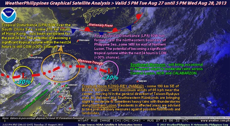
This site has been around a long time and is a wealth of information for the casual observer and the more technical minded. The best bit is their simple, daily satellite analysis which shows the incoming weather systems and where they are forecast to go. It’s written for the layman, so easy to understand regardless of your interest in meteorology.
As well as this they provide links to a lot of the other sites tracking the typhoons along with the model predictions of paths and forecast windspeeds.
Sometimes we find the site is down, but they have a mirror site at www.maybagyo.com (no guesses for the meaning of Maybagyo in English!) which is available almost always…
2. Project NOAH
The website created in conjunction with Pagasa, this displays real time weather data for the whole of Philippines. In addition to the usual things like chance of rain, temp and humidity forecasts, it also has live viewing for a number of Doppler stations around Philippines (the Subic one covers the Metro Manila area, as well as the Tagatay station) which show current rain fall. They also have stream gauges on most the major rivers and rainfall sensors all over the country giving accurate live data of current rain fall. Particularly impressive is their 100 year historical flood maps, showing if where you are is safe should the worst happen!
3. Pagasa
While not always the fastest or most accurate in the Typhoon prediction charts they do display the data in a clean and easy to understand format. If a Typhoon or a Tropical Storm is in the Philippine Area of Responsibility (basically a huge rectangle 500km around Philippines) they will have daily bulletins. Once the storm threatens Philippine Landfall they have updated announcements every 6 hours. They use these to advise on their Storm signals for different provinces. These tell you what to expect weather wise over the next 12 hours.
4. Storm2k
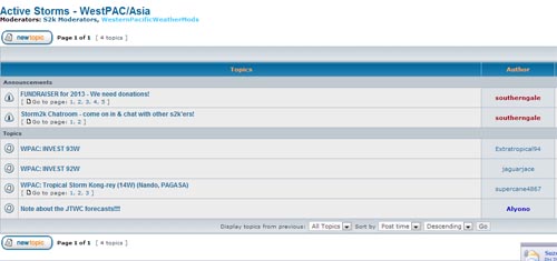
Storm2k is a primarily US site for Atlantic storms, but they have a good up and coming forum for Western Pacific Storms. If your a geek and want to see all the raw data, this is the place to go.
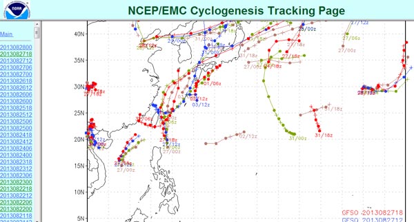
This site is strictly for the geeks. On the left hand side bar are the dates and times. Click on one of these links and then scroll to the bottom to find the prediction tracks for WestPac. If there is a green tick, you can click on it to bring up a map. The lines on the maps which display is the predicted path of a tropical storm or typhoon. These models are predicted by super computers and change daily, adding and dropping storms quickly. If the same storm, on the same path constantly appears, especially over the different computer models, you know there is a good chance of a storm coming!
6) GFS models via TropicalTidBits

A great site which gives you access to the GFS model for 384 hours in advance. Choose the Pacific region and then the ‘wind speed’ map. You can either select the hours, or let it ‘loop’ for all 384 hours. GFS predicted Yolanda on their 384 hr model hitting Bicol at Cat 5, and had it within 300 hours hitting Leyte, where it eventually hit.
Let us know what else you find!

Pingback: The boy that cried “SUPER TYPHOON” | This Is Philippines...·